Enhance Workflow Efficiency Using User-Friendly LiDAR
Picture this: an architect hunched over a workstation at 2 AM, manually redrawing floor plans because a single measurement error cascaded through dozens of CAD sheets. The client presentation is tomorrow, and what should have been a straightforward renovation project has become a nightmare of conflicting dimensions and outdated site data. This scenario plays out in firms worldwide, where traditional 2D drafting methods consume countless hours in rework, coordination failures, and accuracy disputes.
The architectural industry faces a pressing challenge. As projects grow more complex and timelines shrink, professionals need tools that not only capture reality with precision but also integrate seamlessly into modern design ecosystems. The gap between what traditional CAD offers and what today’s projects demand has never been wider. Architects need solutions that deliver both design authenticity and measurable productivity gains.
Enter user-friendly LiDAR technology. Devices like the Galois P4 LiDAR are transforming how architects capture existing conditions and feed accurate spatial data directly into BIM workflows. By bridging the BIM vs CAD divide with accessible scanning tools, firms can eliminate measurement guesswork, reduce costly errors, and dramatically enhance workflow efficiency from the earliest project phases through final delivery.
The Evolution from CAD to BIM: A Foundation for Efficiency
Computer-aided design transformed architectural practice in the 1980s, replacing hand drafting with digital precision. For decades, CAD served as the industry standard, enabling architects to produce clean 2D drawings faster than ever before. Yet as building complexity increased and project stakeholders multiplied, the limitations of flat drawings became painfully apparent. Enter Building Information Modeling—a paradigm shift that moved architecture from lines on a screen to intelligent, data-rich 3D models. Understanding the BIM vs CAD distinction is essential for any firm seeking to enhance workflow efficiency, because this evolution represents more than a software upgrade. It reflects a fundamental change in how architectural information is created, shared, and maintained throughout a project’s lifecycle. Where CAD asks “what does this look like?” BIM asks “what is this, how does it perform, and how does it relate to everything else?” For architects navigating increasingly demanding projects, this shift from static documentation to dynamic modeling creates the foundation upon which modern efficiency tools—including LiDAR scanning—deliver their greatest value.
Key Differences Between BIM and CAD
CAD produces geometry—lines, arcs, and hatches that represent building elements symbolically. A wall in CAD is simply two parallel lines with a fill pattern. In BIM, that same wall carries material properties, thermal performance data, cost information, and structural relationships. This intelligence means that when an architect modifies a wall height in one view, every section, elevation, schedule, and detail updates automatically. The contrast extends beyond individual elements. CAD files exist as isolated documents requiring manual coordination between disciplines. BIM operates as a unified database where architectural, structural, and MEP models reference shared information, catching clashes before they reach the construction site. Error reduction follows naturally: studies consistently show BIM-based projects experience fewer RFIs and change orders because conflicts surface during design rather than during construction. For project lifecycle management, BIM models serve as living documents from concept through facility management, eliminating the information loss that occurs when projects transition between phases using disconnected CAD files.
Why BIM Enhances Workflow for Architects
The efficiency gains BIM delivers stem from eliminating redundant work. In a CAD-based workflow, updating a window schedule means manually cross-referencing floor plans, elevations, and specifications—a process prone to omissions. BIM automates this coordination, freeing architects to focus on design rather than documentation housekeeping. Collaboration improves dramatically when teams work from a shared model rather than exchanging static drawings that become outdated the moment they’re issued. Real-time clash detection prevents the costly discovery of conflicts during construction, where resolving a single coordination issue can cost tens of thousands of dollars and weeks of delay. Perhaps most significantly for workflow efficiency, BIM enables rapid iteration. Architects can explore design alternatives knowing that documentation will follow automatically, rather than avoiding changes because redrawing takes too long. This shift transforms the design process from cautious and linear to exploratory and responsive—exactly what complex modern projects demand. The missing piece for many firms has been capturing accurate existing conditions to feed into these powerful BIM workflows, which is precisely where LiDAR technology enters the picture.
Introducing User-Friendly LiDAR: The Galois P4 LiDAR Advantage
LiDAR—Light Detection and Ranging—works by emitting thousands of laser pulses per second, measuring the time each pulse takes to bounce back from surrounding surfaces. The result is a dense point cloud that represents physical space with remarkable fidelity. While this technology once required specialized operators, bulky equipment, and six-figure budgets, a new generation of user-friendly LiDAR devices has made high-precision scanning accessible to architectural practices of all sizes. The Galois P4 LiDAR exemplifies this accessibility shift, designed specifically for professionals who need accurate spatial data without the steep learning curve traditionally associated with terrestrial laser scanning. For architects already investing in BIM adoption, user-friendly LiDAR represents the critical input layer that feeds real-world conditions into digital models with confidence. Rather than relying on tape measures, photographs, and assumptions that introduce compounding errors, architects can now capture complete spatial reality in minutes and carry that data directly into their design environment.

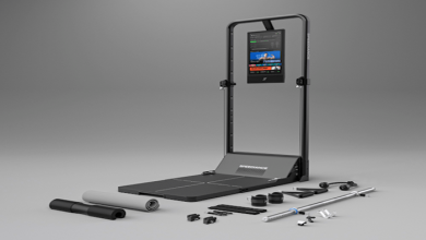
Features of Galois P4 LiDAR
The Galois P4 LiDAR prioritizes the working architect’s needs through thoughtful design decisions. Its intuitive interface eliminates the complexity that once made scanning feel like a specialist discipline—operators can begin capturing data after minimal setup time rather than days of training. The lightweight, portable form factor means a single person can transport the device to site, scan multiple rooms or building exteriors, and return to the office with comprehensive spatial data before lunch. Perhaps most critically for workflow efficiency, the Galois P4 produces output formats that integrate directly with major BIM platforms. Point cloud data flows into modeling software without cumbersome file conversions or third-party translation tools, maintaining data integrity from scan to model. The device handles both interior and exterior environments, adapting to varying lighting conditions and surface materials that challenge lesser equipment.
Benefits for Architects and Designers
Speed transforms project economics when architects adopt user-friendly LiDAR. What previously required multiple site visits with measuring tapes, annotated sketches, and follow-up verification trips collapses into a single scanning session capturing millions of data points. This rapid data capture means design teams spend their time designing rather than documenting existing conditions. The minimal training requirement removes adoption barriers that have historically kept advanced scanning technology confined to specialist survey firms. Junior staff can operate the equipment effectively, democratizing access to precise spatial data across the practice. Design flexibility expands significantly when architects work from complete, accurate point clouds rather than selective manual measurements. Exploring alternative layouts, testing spatial relationships, and validating design assumptions against actual conditions becomes routine rather than exceptional. The confidence that comes from knowing your base data is accurate eliminates the hesitation that slows decision-making and encourages the conservative, play-it-safe approach that produces uninspired architecture.
Achieving Unprecedented Accuracy in Scanning for Design Authenticity
In architecture, a millimeter can matter. When designing interventions within existing structures, the difference between accurate spatial data and approximate measurements determines whether prefabricated components fit on the first attempt or require costly field modifications. Accuracy in scanning has become the defining requirement for architects who refuse to compromise design authenticity—the faithful representation of existing conditions that enables confident, creative responses to spatial challenges. Advanced imaging technology embedded in modern LiDAR devices delivers this precision not through operator skill alone, but through sophisticated engineering that compensates for environmental variables and produces reliable results consistently. For architects, this means trusting the data enough to push design boundaries, knowing that the digital model faithfully mirrors physical reality.
Technology Behind Accuracy in LiDAR Scanning
The precision of user-friendly LiDAR stems from fundamental physics combined with intelligent processing. Laser scanning mechanisms emit pulses at known wavelengths, measuring return times with nanosecond precision to calculate distances accurate to within a few millimeters across typical architectural ranges. The density of these measurements—often hundreds of thousands of points per second—creates a mesh of spatial data so fine that surface details like molding profiles, structural deflections, and subtle geometric irregularities become clearly visible in the resulting point cloud. Error correction algorithms work continuously during capture, compensating for device movement, temperature variations, and surface reflectivity differences that could otherwise introduce systematic inaccuracies. Multi-return capabilities distinguish between surfaces at different depths, preventing false readings from transparent or semi-transparent materials. The high-resolution data output preserves geometric relationships between building elements with enough fidelity that architects can extract reliable dimensions, angles, and spatial relationships directly from the scan data without returning to site for verification measurements. This technological sophistication operates invisibly behind intuitive interfaces, delivering professional-grade accuracy without demanding specialized knowledge from the operator.
Real-World Applications for Design Authenticity
Renovation projects demonstrate the value of accuracy in scanning most dramatically. When an architect designs a contemporary insertion within a century-old warehouse, every beam position, floor undulation, and wall deviation matters. LiDAR captures these imperfections faithfully, allowing designers to celebrate rather than fight existing character while ensuring new elements integrate precisely. Heritage conservation demands even greater rigor—documenting ornamental stonework, recording structural movement over time, and creating archival records that serve both immediate design needs and long-term preservation goals. Complex site analyses benefit similarly when topographic scanning reveals drainage patterns, vegetation boundaries, and neighboring building relationships that inform site strategy. In adaptive reuse projects, where industrial structures become residential or commercial spaces, accurate scanning reveals structural systems hidden behind later additions, enabling architects to make informed decisions about what to retain, expose, or modify. The common thread across these applications is design authenticity: the ability to respond honestly to existing conditions rather than imposing idealized geometries that conflict with built reality. When architects trust their base data completely, design decisions become bolder and more site-specific, producing architecture that feels inevitable rather than forced.
Practical Solutions: Integrating LiDAR into Architectural Workflows
Adopting user-friendly LiDAR technology delivers its full value only when scanning becomes a natural extension of existing design processes rather than an isolated data-collection exercise. The goal is a continuous pipeline where physical reality flows into digital models without friction, enabling architects to maintain momentum from site investigation through design development. Successful integration requires understanding both the technical connections between scanning hardware and BIM software, and the procedural adjustments that make scanning a routine part of project delivery rather than a special event requiring outside consultants.
Workflow Integration Steps
Effective integration begins before anyone arrives on site. During project kickoff, teams should identify which existing conditions require scanning—full building interiors, structural elements only, façade geometry, or surrounding context. This scoping exercise prevents both over-scanning, which generates unnecessarily large datasets, and under-scanning, which forces return visits. On site, the scanning sequence follows a logical spatial progression: exterior context first to establish overall building positioning, then interior spaces organized by floor level or functional zone. Each scan station overlaps with adjacent captures, ensuring the registration software can stitch individual scans into a unified point cloud without gaps. Back in the office, raw scan data undergoes registration and cleanup—removing noise, aligning coordinate systems with project north, and setting appropriate density levels for the intended use. The processed point cloud then imports directly into the BIM environment as an underlay, serving as the authoritative reference against which all new modeling occurs. Architects trace walls, floors, and structural elements directly over the point cloud, confident that their digital model matches built reality. This scan-to-BIM pipeline transforms accuracy in scanning from an abstract quality into a tangible workflow advantage, eliminating the iterative cycle of measure, model, discover discrepancies, and remeasure that plagues traditional approaches.
Tools and Software Compatibility
Modern BIM platforms have embraced point cloud integration as a core capability. Autodesk Revit accepts point cloud formats natively, allowing architects to load scan data as a referenced underlay visible across all views—plans, sections, and 3D perspectives simultaneously. ArchiCAD offers similar functionality through its point cloud engine, enabling direct modeling against scanned reference geometry with real-time visual feedback. Vectorworks provides point cloud support that appeals to design-focused practices prioritizing form exploration alongside technical documentation. The Galois P4 LiDAR outputs industry-standard formats compatible with these platforms, meaning architects avoid the frustrating intermediary conversion steps that historically created bottlenecks and introduced potential data degradation. Beyond the primary BIM environment, complementary tools handle specialized tasks: CloudCompare for point cloud analysis and comparison, Recap for scan registration and management, and PropTech platforms like Realsee that transform spatial scan data into immersive digital twin experiences for client presentations and stakeholder collaboration. The key principle guiding software selection is maintaining an unbroken chain of accuracy from physical scan through final construction documentation—every file conversion or manual intervention represents a potential failure point where precision degrades. User-friendly LiDAR devices designed with this interoperability in mind reduce the technical overhead that once made scan-to-BIM workflows viable only for large firms with dedicated digital fabrication teams.
Step-by-Step Guide: Implementing LiDAR for Enhanced Efficiency
Moving from concept to practice requires a structured approach that minimizes disruption while maximizing returns. The following implementation framework helps architectural teams adopt LiDAR scanning methodically, building competence and confidence through each project phase.
Planning and Preparation Phase
Begin by defining clear scanning objectives tied to project deliverables. Identify which spaces require full volumetric capture versus targeted detail scans—a complete interior survey demands different planning than documenting a single façade elevation. Walk the site beforehand to note access constraints, lighting conditions, and potential obstructions that affect scan station placement. Prepare the Galois P4 LiDAR by charging batteries fully, confirming storage capacity for anticipated data volumes, and verifying firmware is current. Establish a coordinate reference system before scanning begins, placing control targets at known positions that align with your project’s spatial framework. This preparation typically requires thirty minutes of forethought but saves hours of post-processing corrections.
Execution and Data Processing Phase
Execute scans systematically, working through predetermined station positions with sufficient overlap between adjacent captures. Monitor data quality on-device during capture, checking point density and coverage completeness before moving to the next position. Once scanning concludes, transfer raw data to your processing workstation and run registration algorithms to merge individual scans into a cohesive point cloud. Clean the dataset by removing transient objects—people, vehicles, temporary equipment—that don’t represent permanent conditions. Downsample appropriately for your BIM platform’s performance capabilities while preserving critical geometric detail at connection points and complex intersections.
Post-Processing and Quality Analysis
Validate accuracy by comparing scan measurements against known reference dimensions at multiple locations throughout the dataset. Cross-check critical relationships—floor-to-ceiling heights, column grid spacing, opening dimensions—against any available documentation to confirm consistency. Import the verified point cloud into your BIM environment and begin modeling, flagging any areas where scan coverage proves insufficient for confident interpretation. After completing the scan-to-BIM conversion, quantify efficiency gains by comparing time invested against traditional survey methods on similar projects. Document lessons learned regarding station placement, scanning sequences, and processing workflows to refine your approach for subsequent projects, building institutional knowledge that compounds efficiency improvements over time.
Bridging Physical Reality and Digital Design with LiDAR-Enabled BIM Workflows
The trajectory from CAD to BIM represents more than technological progress—it reflects architecture’s evolution toward integrated, intelligent design processes where information flows freely between disciplines and project phases. Within this landscape, user-friendly LiDAR technology like the Galois P4 LiDAR serves as the essential bridge between physical reality and digital modeling, delivering the accuracy in scanning that architects need to produce work grounded in design authenticity rather than approximation.
The practical steps outlined here—from understanding the BIM vs CAD distinction to implementing structured scan-to-model workflows—provide a clear path for firms ready to eliminate measurement uncertainty and reclaim hours lost to rework. By combining accessible scanning hardware with robust BIM platforms, architects gain both the confidence to push creative boundaries and the efficiency to deliver projects on time and within budget. Firms that embrace these tools now position themselves not merely to survive increasing project complexity but to thrive within it, offering clients faster turnaround, fewer errors, and designs that respond authentically to the built world. The technology is ready; the competitive advantage belongs to those who act.